
Planners envision grand global boulevard along US 1

The Miami-Dade Transportation Planning Organization (TPO) has wrapped up a US 1 multimodal and roadway intersection analysis in Coral Gables and has presented recommendations with the grand vision of transforming US 1 into a boulevard.
Similar to many of the grand boulevards around the world, US 1 connects Miami’s urban core with dense mixed-use suburbs, the study notes.
Land uses and development along the corridor have been rapidly changing, which incentivizes the evolution of the corridor into a more urban pedestrian-supportive environment, according to the analysis.
The traffic study, which was slated to be completed back in December, has assessed vehicle and pedestrian crossing access along US 1 from Southwest 27th Avenue to Southwest 72nd Street.
Based on the analysis, three focus areas were targeted to develop transportation solutions, which include 57th Avenue to Southwest 72nd Street, Granada Boulevard and Southwest 42nd/LeJeune Road.
Analysts crafted short-term and long-term recommendations for those three locations.
At US 1 and Southwest 57th Avenue, TPO recommended improved short-term solutions such as creating bulb-outs, adding high-emphasis crosswalks, creating pedestrian refuges within medians, staggering stop bars for vehicles, eliminating right-turn slip lanes, and implementing the Underline. Long-term, an elevated bike path with pedestrian walkovers is needed, the study said.
Along US 1 and Granada Boulevard, the project working group recommended creating bulb-outs, adding high-emphasis crosswalks, creating pedestrian refuges within medians, eliminating right-turn slip lanes, implementing the Underline, and creating a unified aesthetic and landscape theme inspired by the multi-way boulevard concept. Long-term solutions are to also elevate a bike path featuring a circular bridge across US 1 to the Underline.
On US 1 and LeJeune Road /Southwest 42nd Avenue /Grand Avenue, analysts recommended adding and enhancing crosswalks, creating pedestrian refuges within medians, and decreasing pedestrian crossing distance by adding extra pavement and bulb-outs short term, and creating a traffic circle at Ponce de Leon / Southwest 42nd Avenue / LeJeune Road as a long-term solution.
The analysis reviewed the current daily travel demand as well as growth into the year 2045 by using the Southeast Regional Planning Model.
The study area growth patterns from the travel demand modeling effort were used to develop a traffic model of the targeted intersections for estimating future 2045 traffic operations conditions and planning for what might be in store for future transportation users in the area during peak hours nothing is done at all.
The purpose of the traffic analysis is not only to understand the levels of delay and congestion motorists will face in 2045, according to the report, but also to serve as a baseline in developing capacity and solutions to reduce pedestrian crossing delay, which in turn is geared to improve pedestrian signal compliance and safety.
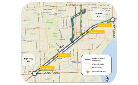
The study also pinpointed enhanced bicycle connection opportunities that link the Metrorail stations along US 1 and the Underline with downtown Coral Gables. One designated route follows Ponce de Leon and designates space for bicycles on the wide sidewalks. This technique, which is common in many European cities, has recently been used on a strip of Southwest 152nd Street in south Miami-Dade.
The other designated route would paint striped bike lanes on Suarez Street, Riviera Drive, and University Drive. This is consistent with overall Coral Gables city officials’ strategic plans and connects with existing bike lanes on Malaga Avenue and Galiano Street in the downtown area, the report says.
Miami and South Miami were also included in the study. All of the funding came from the Federal Highway Administration Surface Transportation Block Grant Program urban funds.
The program is a federal-aid transportation program, administered by the Federal Highway Administration and Federal Transit Administration, that drives funds to states and localities for transportation improvement projects.
Analysts said the report is just the beginning of a transformation. Broad community support, along with collaboration from municipalities and transportation agencies, will be crucial, the traffic study said.
It points to some smaller enhancements that can be plugged into street resurfacing projects and operating modifications once there is a consensus between the cities, the county and FDOT.


MiamiCityMan
April 27, 2023 at 3:25 pm
If this is proposed by FDOT, run away. It’s all about ruining more of Florida by paving it over.